From the Ship's Log: Friday, May 11, 2012
Lisbon, Portugal
11:39am
Pilot embarked
12:42pm
Safely docked
Today we dock in Lisbon, Portugal, the second port on this cruise. We will stay docked here tonight, and will leave tomorrow. I am not exactly sure why, although there is a lot to see and do in Lisbon.
Unlike most other ports, the ship will not arrive at the dock until noontime; one reason is that it takes the ship a good while to go up the Tagus River estuary to the dock at the city of Lisbon; the dock is a good fifteen miles from the open ocean, and the ship goes quite slowly up the estuary.
This afternoon, we'll take a bus tour that will introduce us to the city of Lisbon, take us out to the beach resort town of Estoril, and then bring us back to the harbor with a stop at the famous monument to Prince Henry the Navigator. We think that the introduction to Lisbon will enable us to be on our own tomorrow as we explore the city by ourselves, figuring out the local transportation as we go.
Arriving in Lisbon
Yesterday was a sea day; although the Azores are part of Portugal, they are a good 900 miles from the Portuguese mainland:
I wanted to see us arrive in Lisbon, and especially see the trip up the Tagus River estuary, as we were supposed to go under a large suspension bridge, but since we weren't supposed to start up the estuary until well after nine in the morning, I had time to sleep in just a while. Still, I got up before the other guys, and went up on deck to see where we were.
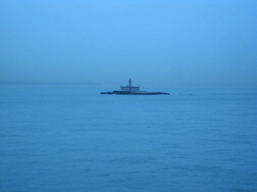
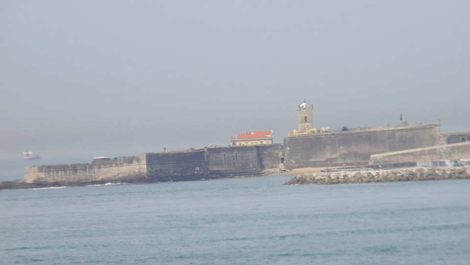
When I got up on deck, I found we were just past the Fortaleza de São Lourenço da Cabeça Seca, built on a small island in the center of the entrance to the Rio Tejo (Tagus). Navigational lights were being displayed from the fort in 1693, perhaps much earlier. The island and fort were located about 2 miles southeast of the Fortaleza de São Julião da Barra that we passed a few minutes later (after Fred had joined me up on deck). A short time after that, we passed the official entrance to the Lisbon harbor (the Tagus Estuary) and the ultramodern Harbor Administration office. As soon as we passed it, I noticed that Harbor Administration had sent out the cutter with our harbor pilot. Assuming that he came on board a few minutes after this picture was taken, that puts the time at about 11:30AM.
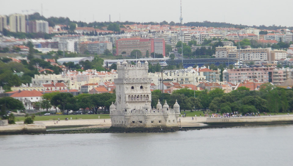
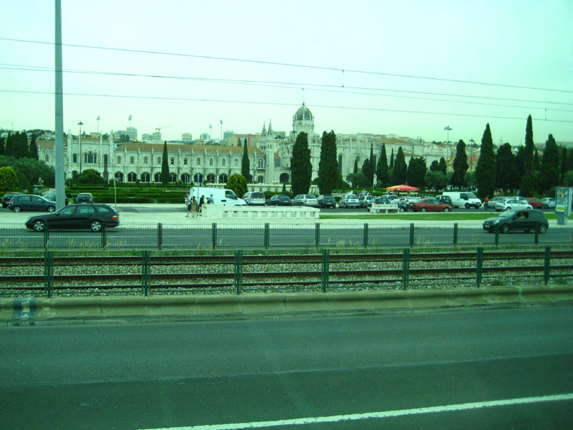
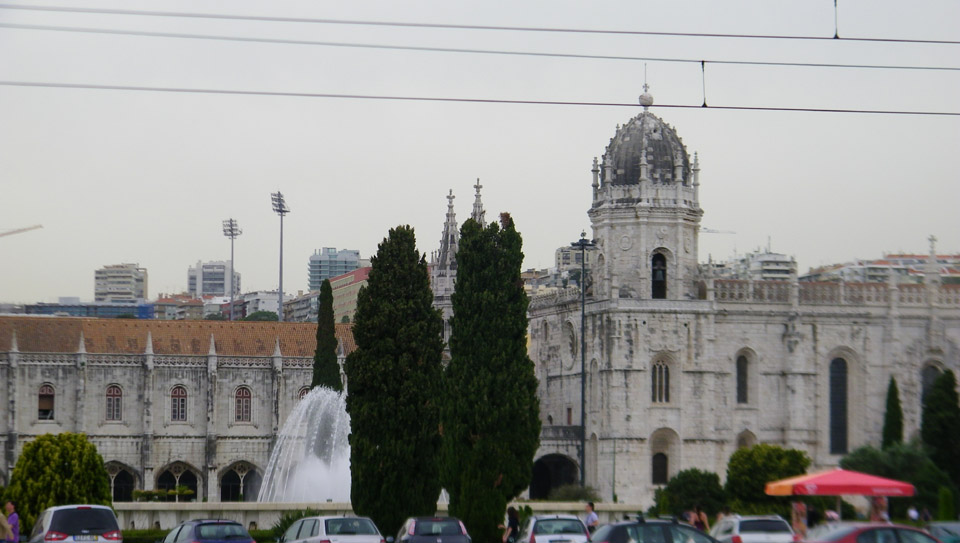
The next point of interest that we passed was Belém Tower (in Portuguese "Torre de Belém," or the Tower of St Vincent). It is a fortified tower and a UNESCO World Heritage Site (along with the nearby Jerónimos Monastery) because of the significant role it played in the Portuguese maritime discoveries of the era of the Age of Discoveries. The tower was commissioned by King John II to be part of a defense system at the mouth of the Tagus River and a ceremonial gateway to Lisbon. The tower was built in the early 16th century and is a prominent example of the Portuguese Manueline style. The structure was built from lioz limestone and is composed of a bastion and the 100 foot, four story tower. It has incorrectly been stated that the tower was built in the middle of the Tagus and now sits near the shore because the river was redirected after the 1755 Lisbon earthquake. In fact, the tower was built on a small island in the Tagus River near the Lisbon shore.
Next, we passed the former Palace Santa Catarina, which is now an art museum and popular viewing spot right on the estuary. From a distance, we could view one of the modern sculptures outside the museum.
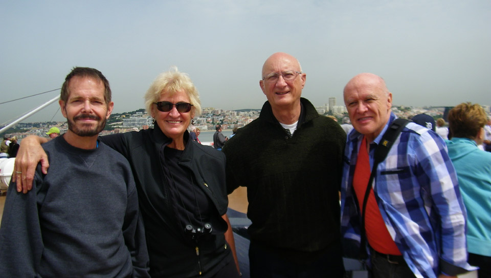
And shortly after that, we passed the Discoveries Monument. I won't go into detail here, as we stopped at that monument at the end of our bus tour this afternoon. In this view of the monument, you can see the ornate Archaeology Museum in the background. And a bit further on, we passed the huge Museum of Electricity. By this time, MaryEllen and Jim and Greg had also joined Fred and I here on the bow of the Noordam, and Fred snapped a picture of the rest of us.
Fred took some interesting pictures of the shoreline as we passed along, and you can have a look at them by clicking on the thumbnails below:
I didn't take as many individual pictures, but you can also look at a few of mine:
I also tried my hand at another panorama, this time stitching four pictures together. Because the boat was moving and the light was changing, the transitions are not very subtle, but you can have a look at it below:
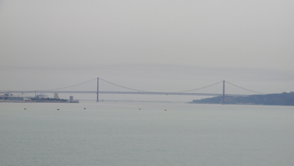
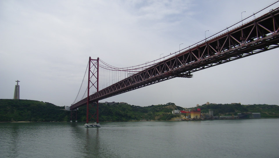
The last landmark we'd pass before docking is the "April 25th Bridge."
April 25th Bridge - Stock Shot
The "25th of April Bridge" is a suspension bridge connecting the city of Lisbon to the municipality of Almada on the left (south) bank of the Tejo (Tagus) River. It was inaugurated on August 6, 1966 and a train platform was added in 1999. Because of its design and coloring, it is often compared to (and mistaken for) the Golden Gate Bridge. In fact, it was built by the same company (American Bridge Company) that constructed the San Francisco-Oakland Bay Bridge (but not the Golden Gate), also explaining its similarity in design. With a total length of 7,000 feet, it is the 21st largest suspension bridge in the world. The upper platform carries six car lanes, and the lower platform carries two train tracks. Until 1974, the bridge was named Salazar Bridge (Ponte Salazar).
I hope you'll pardon my use of a stock shot here; there was no vantage point from the ship or from our tours of Lisbon that could have afforded a picture of the bridge in its entirety (although below you'll see an attempt to stitch one together). Fred did get one picture of almost the entire bridge but it was from a long ways away and the morning weather wasn't very good.
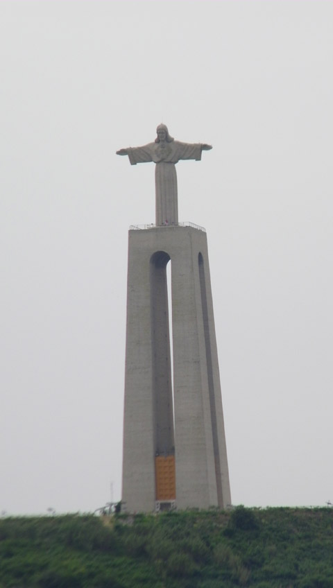
From the late 19th century there had been proposals to build a bridge for Lisbon, but none was constructed- at least not at this point. But in 1958 a new Government commission recommended building the bridge, choosing the southern anchor point adjacent to the recently built monument to Christ the King (Cristo-Rei). In 1960, a United States consortium won the bidding competition, and construction began on 5 November 1962. Forty-five months later (six months ahead of schedule) the bridge was inaugurated on 6 August 1966. Presiding at the ceremony was the President of Portugal, and the bridge was named in honor of a former Prime Minister.
The bridge cost four lives (out of 3,000 workers), 2,185,000 man-hours of work and $225 million in current dollars. In 1974, Portugal saw the "Carnation Revolution," and the bridge was renamed the 25 de Abril Bridge, the day the revolution had occurred. (Some people call it "the bridge of the angry bees" for the sound you can hear when you are near it- tires going across the bridge's open gratings.)
Both Fred and I made movies and took pictures as we passed under the bridge. It's impossible to say which one's I should include here, so because pixels are cheap, I'll include both. We'll start with Fred's movie and pictures (be patient while his movie shows you some of the Lisbon shoreline along the Tagus):
00:00
00:00
Click on the thumbnails below if you want to see some of his pictures:
I stitched together four pictures taken from the exact center of the stern try to get the whole ship and the entire bridge into one picture. I had to take the pictures quickly, because the ship was moving and the proportions were changing every second. The end result wasn't too bad:
Now for my movie and pictures:
00:00
00:00
Click on the thumbnails below to see some of my pictures:
Quite often, landmarks like this one are used in television shows and movies; think how many times you've seen the Colosseum in Rome, or the San Francisco cable cars in movies. But I can only find one movie in which the April 25th Bridge was used. Here is a still from that movie (you know it's this bridge because you can see the monument to Christ the King on the hill in the background):
I am sure you won't guess the movie from the still; there are no identifying characters or objects- other than the bridge. You might not even guess the movie from the clip (Please excuse the first eight seconds of the clip- I have no idea what happened. And if the aspect ratio seems wrong, please excuse that, too!):
00:00
00:00
As we came under the bridge, I could tell that the ship was moving slower and slower. The reason becomes apparent when you look at where we docked:
We actually docked at an industrial dock just a mile or two south of the center of Lisbon. There is another cruise ship dock further up the estuary and closer to downtown, but perhaps ships as large as ours can't fit there, or maybe the berths there were taken. We will see some views tomorrow of those berths, and, indeed, there were ships there.
By a quarter of one we were all docked, and the three of us had some lunch in preparation for the 1:30PM departure of our bus tour to Lisbon and Estoril.
We met in the Vista Lounge at 1:30PM, and fifteen minutes later we were off the ship and headed to the bus parking area for our tour bus. In the aerial view you saw earlier, I should point out that the gangway led directly into the cruise ship terminal building and from there to the parking area. We didn't have to wander through the containers and equipment piled on this industrial dock.
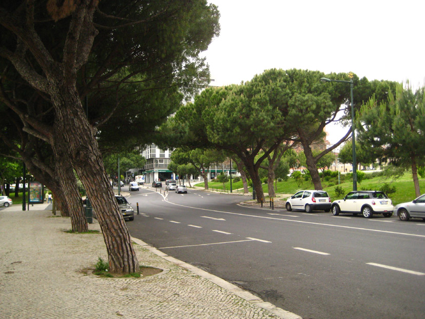
The bus wound its way through the city, heading towards the viewpoint at the top of Parque Eduardo VII. Fred tried to take some pictures through the bus windows, but they were heavily tinted and the brighter it was outside the more the green tint showed up. But I did include six representative pictures here; click on the thumbnails below to view:
The trip to the park took about twenty minutes, and on the way we saw lots of places we'd like to visit tomorrow. Eventually, the bus turned onto Alameda Cardeal Cerejeira, parked and let us get out for a short stop in the park. (I think its interesting that in the aerial view below, you can easily see the portion of alameda Cardeal Cerejeira that appears in my photograph.)
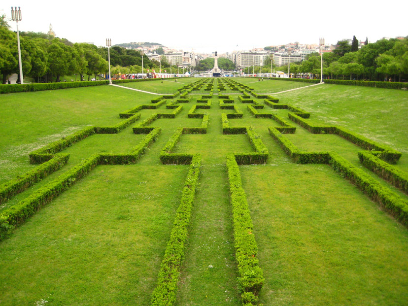
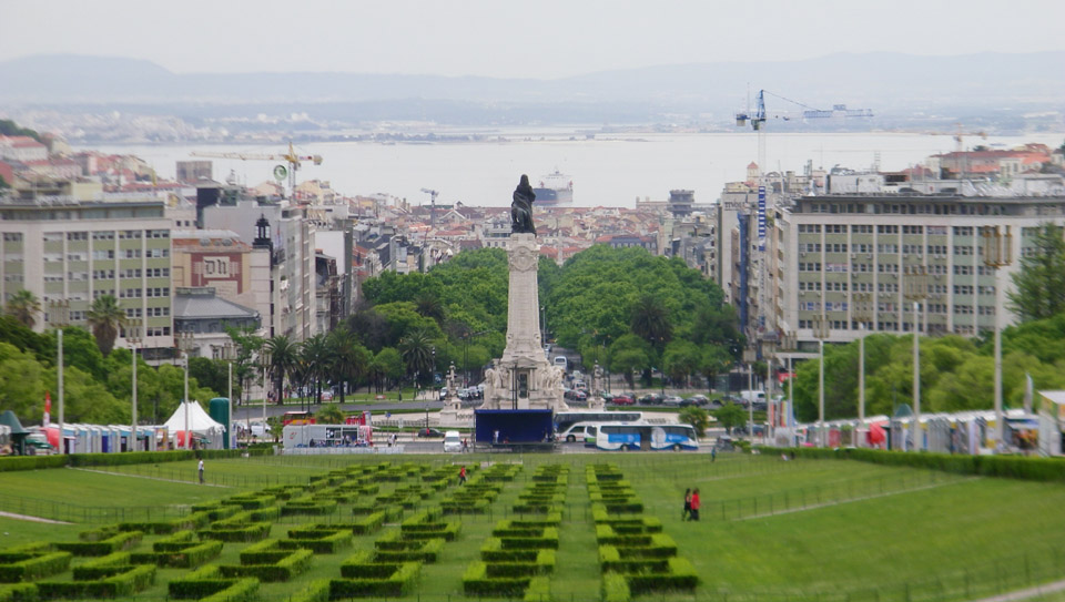
Named after Britain's Edward VII who visited the city in 1903 to reaffirm the Anglo-Portuguese alliance, this is the largest park in central Lisbon. With neatly clipped box hedging flanked by mosaic patterned walkways, it stretches uphill from Marquês de Pombal Square to a belvedere at the top with fine views.
In the square, you can see the monument to the Marquis of Pombal, the prime minister responsible for the rebuilding of Lisbon following the Great Earthquake in 1755, showing him standing on a column with his hand on a lion (symbol of power) and his eyes directed to the downtown area that he rebuilt.
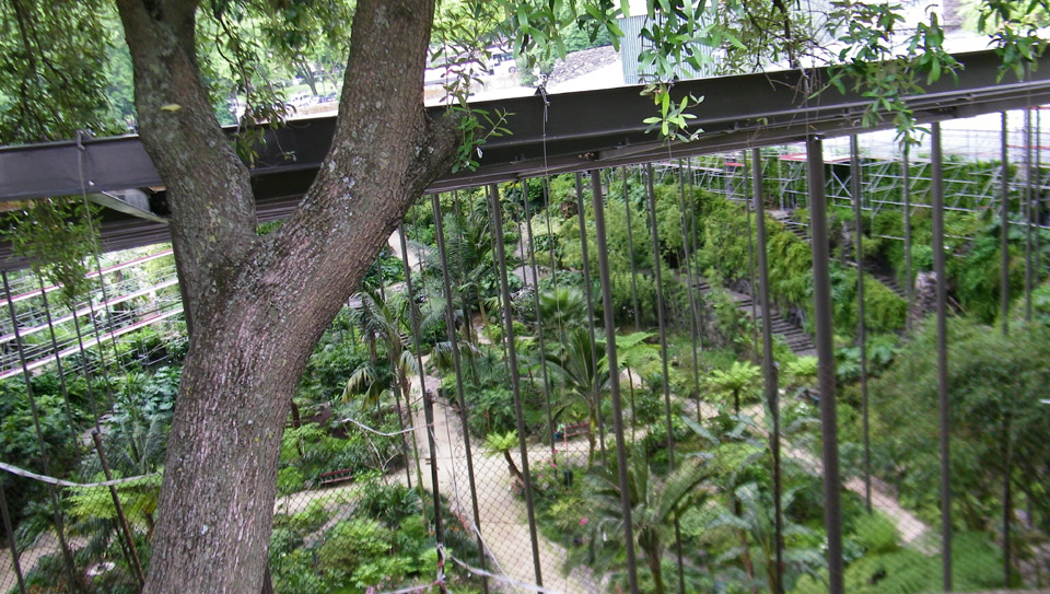
The big attractions within the park are the two estufas, the hothouse (with the more exotic plants) and the greenhouse("Estufa Fria") filled with tropical plants, ponds, and endless varieties of palms and cacti.
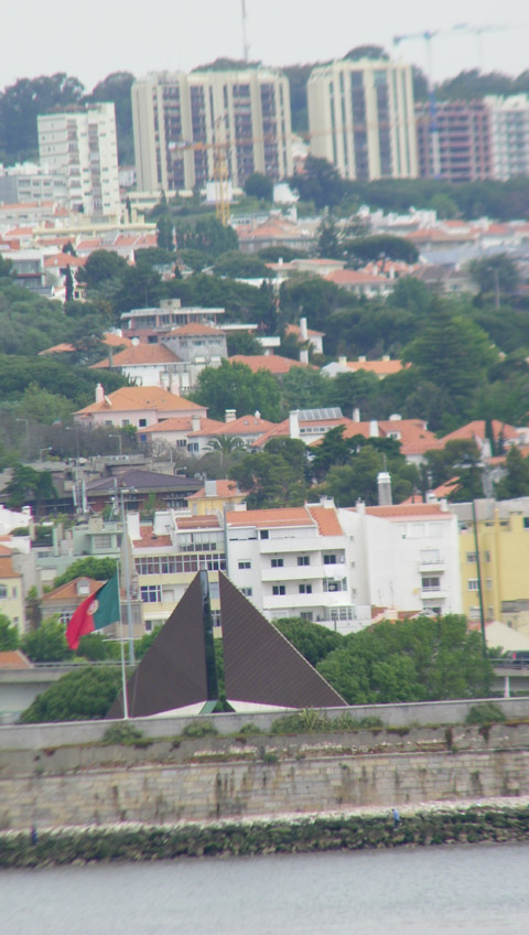
At the top of the slope, on a small esplanade marked by four large pillars, stands a modern monument that commemorates the 1974 Revolution. The monument was created by João Cutileiro, a Portuguese sculptor. It consists of a fountain in the shape of a rock, supported by large struts and set in a basin with a crumbling wall and broken columns.
I made a movie from our vantage point near the 1974 Revolution monument, and you can watch it with the player below:
00:00
00:00
I took two more good pictures of Fred and Parque Eduardo VII before we had to pile back into the bus for our trip to Estoril. You can click on the two thumbnail images below to have a look at them:
The territory of Estoril has been occupied at least since the first millennium, owing to its climatic conditions and favourable environment; the Phoenicians, Romans and Arabs all selected this area for its strategic place in Western Europe, and there are remnants of all these civilizations here. With these occupations, Estorial inherited a rich cultural patrimony, architecture, toponymy, habits and customs. The region was finally brought under Christian control in 1147, during the Reconquista.
Owing to its strategic place, the Estoril region was intimately linked to the Portuguese Age of Discovery, and all the dynamic social and cultural upheavals that it originated. Its solid fortifications are a testament to the innumerable attacks by Spanish, French and English pirates and privateers; the many forts that dot the barrier between land and sea are symbols of the resistance and battles that secured Portuguese independence and national interests. At the end of the monarchy, it was in the waters of Estoril that many sought refuge and escape; aristocrats, nobles and other exiles escaped through the ports along the Estoril coast to escape the Republican forces.
In the hilltop enclave of Monte Estoril is the Verdades-Faria Museum, built in 1917. In 1942, the building was dedicated to the support of the arts and artists, and was the beginning of a lively artistic community- to which many artists gravitated.
During the Second World War, the region was the centre of spies and diplomatic secrecy, situations that provided the region with a cosmopolitan atmosphere and sophistication. It became an international tourist destination both during and after the Second World War; during that time, several dignitaries and exiles came to Estoril: the regent of Hungary lived and died in exile here after the Second World War; the Infante Juan, Count of Barcelona (father of Juan Carlos I of Spain) and the King resided in the territory, as did Umberto II of Italy and Carol II of Romania. It was also in this location that former Portuguese dictator António de Oliveira Salazar had a summer house. It was he who ordered the construction of the E.N.6 motorway, in order for him to quickly travel by car between Cascais and Lisbon with fewer stops- and less chance he would be easily recognized in transit (as many were murderously unhappy with him).
While we took a newer expressway from Lisbon to Estoril (the A5), we did return on the E.N.6 (now known as the Avenida Marginal) and saw much of the oceanside scenery. Our trip to Estoril was about an hour each way.
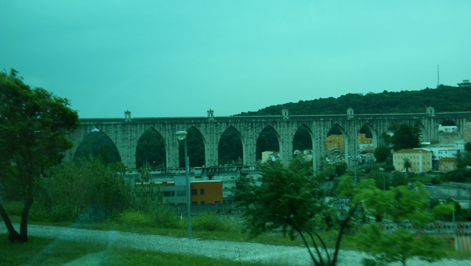
Again, Fred found that the tinting on the bus windows ruined most of the pictures he tried to take, but if you can ignore the green cast to the picture, he got a very good one of an ancient aqueduct- still functioning, we are told.
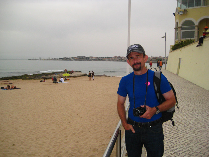
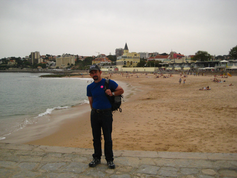
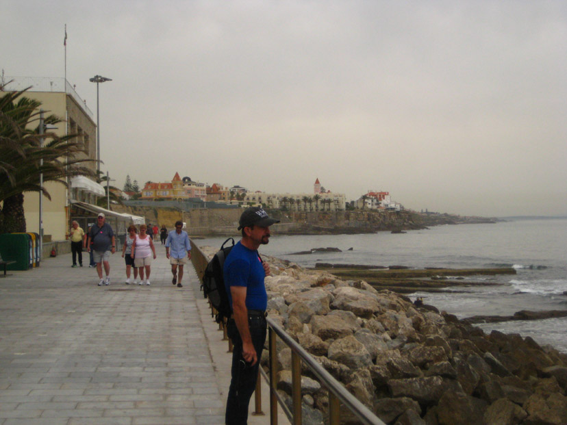
We got to Estoril in about an hour, and the bus parked alongside the Gardens of Casino Estoril. The Casino is the largest casino in Europe, and during World War II was reputed to be a gathering spot for espionage agents, dispossessed royals, and wartime adventurers. It was the inspiration for Ian Fleming's 007 novel Casino Royale. We would be exploring on our own for a couple of hours; from the bus, our tour guide led us south to the corner of Avenida Aida and Marginal de Cascais- a busy, four-lane street. There, she showed us the underground passageway to the beach and gave us a time to be back at the bus. The three of us took the passageway, and soon found ourselves at Tamariz beach.
00:00
00:00
One of the first things I did was make a movie; watch it with the player at left and it will orient you to the beach area.
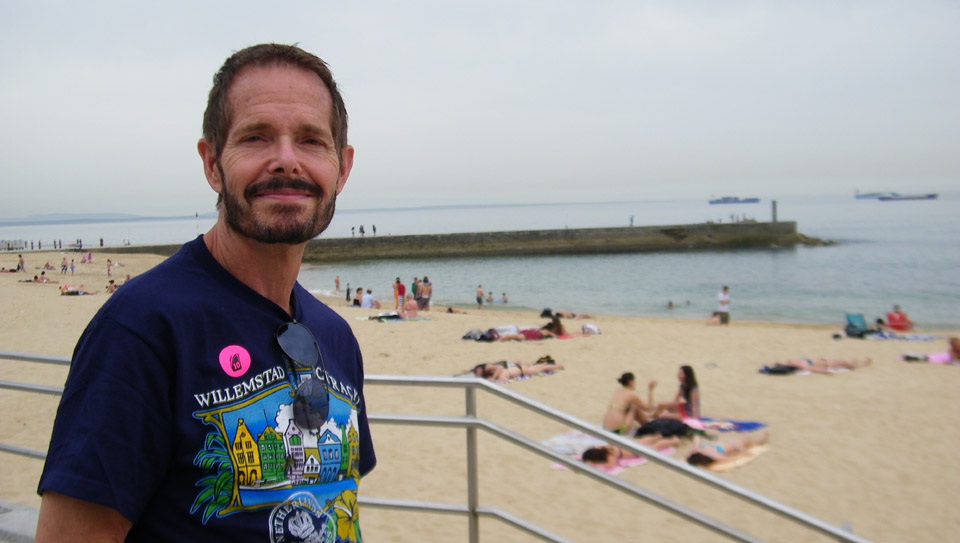
We were on a walkway just above the actual beach and below a row of buildings that might have been either shops or summer rentals. Towards the west, we could see the city of Cascais off in the distance. Looking east, Fred could see a breakwater behind me that looked as if it might offer good views back this way, so we planned to go out there. I guess the thatch umbrellas on the beach have been there a good while; you can even see them on the aerial view.
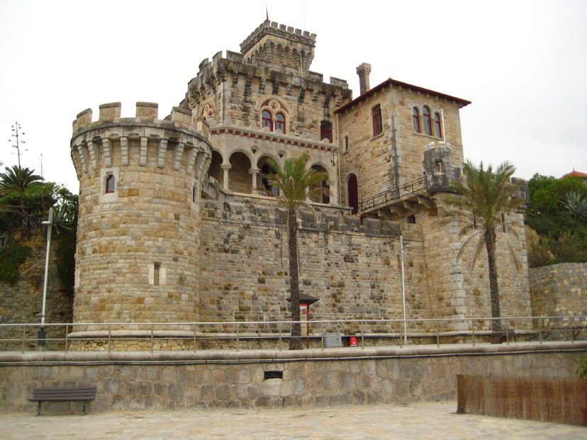
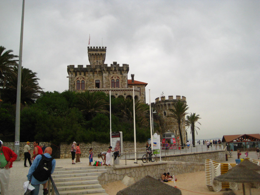
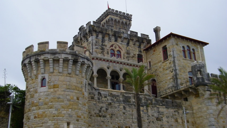
We could see, at the eastern end of the beach, a building that looked like a castle. We didn't know what it was, but we are going to walk in that direction anyway, so maybe we'll find out. We headed east and at the end of the beach, turned for another look west towards Cascais.
Just at the eastern end of Tamariz Beach stands, we found out, Forte da Cruz, or Old Fort of Santo Antonio da Cruz, a former fortress that protected the Bay against invaders. That function became obsolete in the 19th century, and so in 1894 it was bought by financier Joao Martins de Barros. He transformed it into a villa named Chalet Barros. It has, apparently, been well kept-up, and the outside is rich in colorful Gothic detail.
The breakwater began in front of Forte da Cruz, and we started walking out. As we began to get out on the concrete walkway, we began to get good views of most of Tamariz beach. Click on the thumbnails below to see a couple more shots I took from out on the breakwater:
Fred took a number of good pictures while we were out on the breakwater, and you can have a look at some of them if you click on the thumbnails below:
I tried another of my massive panoramas, stitching seven pictures together this time to get a 180° view around from the breakwater. Again, the sky is difficult to smooth, but you can look at the result in the scrollable window below:
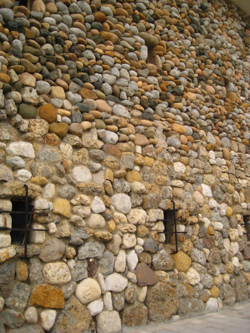
We walked back in to the shore from the breakwater, and then continued walking eastward. We wanted to find another way up from the beach to the Marginal de Cascais so we wouldn't have to go back the way we came. At one point, Fred took a picture looking back west of Greg and I, and immediately after I returned the favor with a picture of Fred and the view eastward. At one point, we passed a very interesting residence, which was up above the beach atop an interesting retaining wall made of boulders.
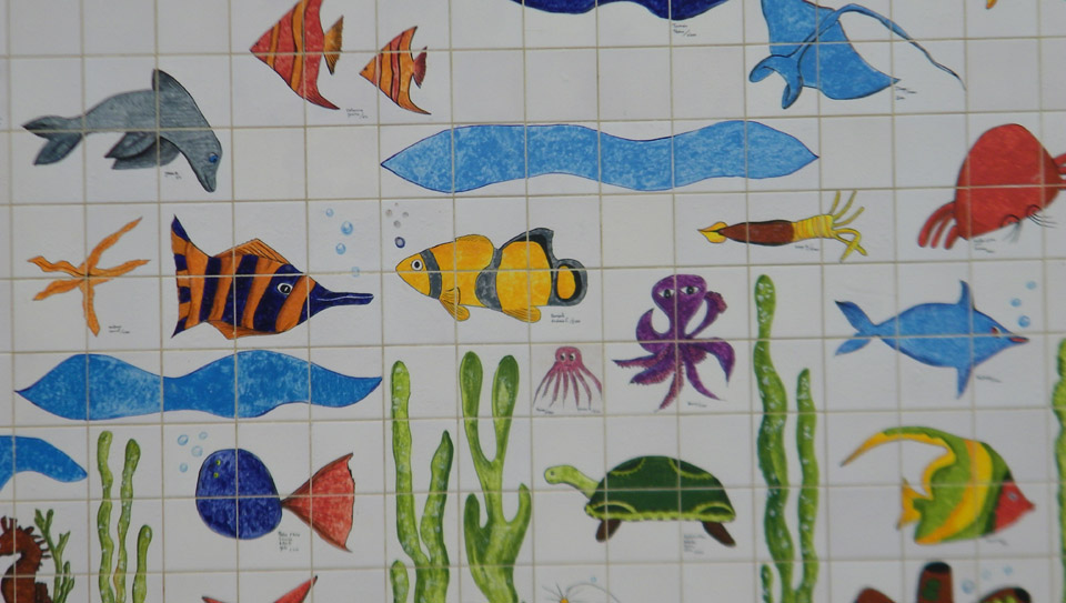
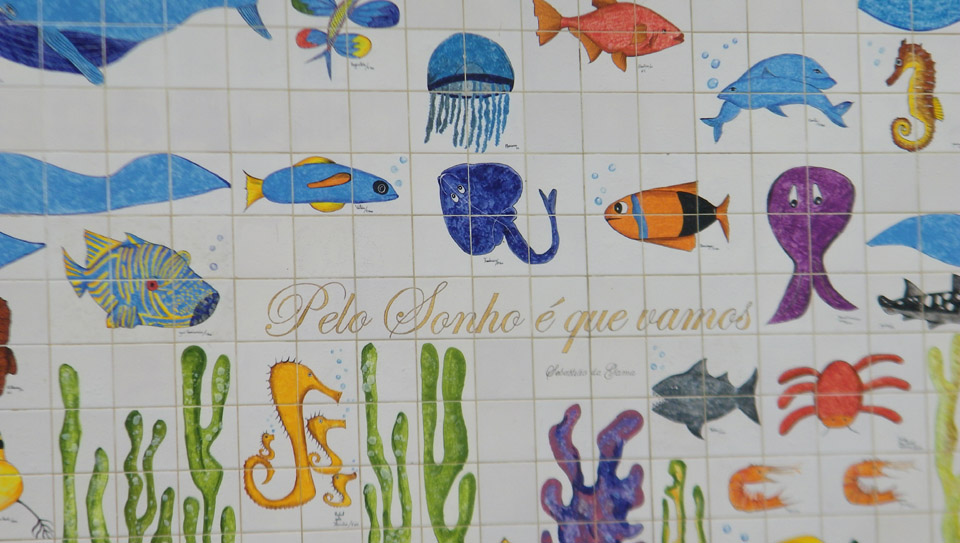
Just before we reached the ramp back up to the street, we passed a very colorful tiled wall, where the various tiles had different fish and other sea creatures baked onto them. While Greg was taking a picture (see left), Fred got a couple of good close-ups of the tilework, and you can have a look at them here and here.
We got back up to the Marginal de Cascais and began walking westward to get back to the place the tour bus was parked.
Along the way back, Fred was snapping lots of pictures, and I picked a few of them to include here. They are views of the architectural detail on some of the buildings we passed, and one picture of the rail line that links Estoril and the city of Lisbon. Click on the thumbnails below to look at these pictures:
It took us only a few minutes to get back to the gardens on the ocean side of the Casino Estoril.
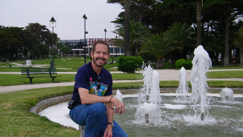
When we got back to the gardens, we had about a half-hour before we were to be back at the bus, so Fred and I wandered across the area for a while. Down by the Marginal, there was a nice little fountain where Fred had me kneel down for a picture. And out in the middle of the area was a statue of Fausto Cardoso de Figueiredo. Estoril was born in 1914 because of this one man's dream, and it was to become the most cosmopolitan holiday spot in Portugal until the rise of the Algarve. Fausto helped develop the transformation of the region, mainly Tamariz Beach, and Estoril Casino.
We were back on the bus in plenty of time, and it headed off back to Lisbon, this time following the coast road. Fred took a number of pictures through the bus window, but sad to say the tinting made everything green again. So we'll skip over those candid shots.
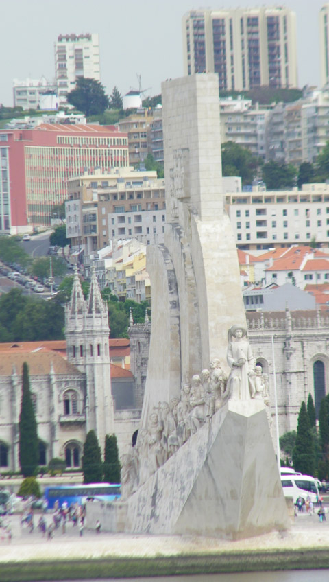
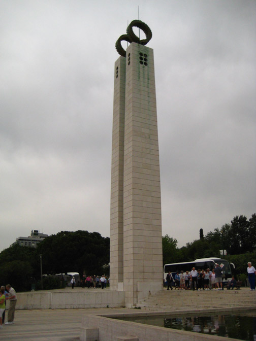
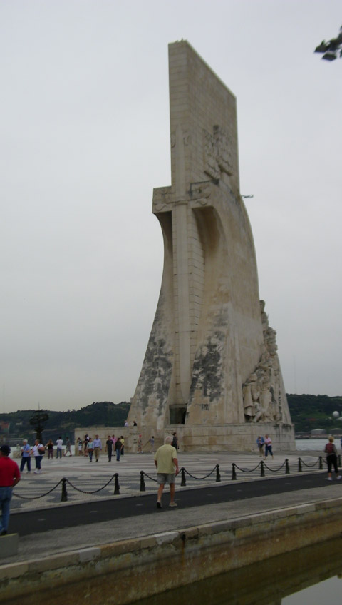
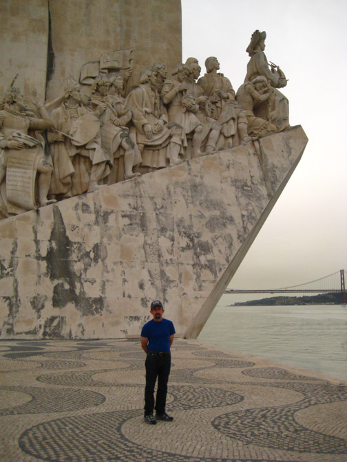
When the bus arrived back in the western part of Lisbon, it made a stop at the Monument to the Discoveries.
The Monument to the Discoveries is located on the north side of the Tagus River estuary, where ships departed to explore and trade with India and the Orient. The monument celebrates the Portuguese Age of Discovery (or Age of Exploration ) during the 15th and 16th centuries.
The monument was conceived in 1939 by Portuguese architect José Angelo Cottinelli Telmo and sculptor Leopoldo de Almeida as a temporary beacon during the Portuguese World Fair opening in June 1940. It represented a romanticized idealization of Portuguese exploration. It was originally intended to be temporary and indeed, in 1943, it was demolished. In 1958, the government promoted the construction of a permanent monument, and it was completed in 1960. It was formed in cement and rose-tinted stone, and the statues were sculpted from limestone excavated from the region of Sintra. The new monument was an enlarged version of the original to celebrate the fifth centennial of the death of Infante Henry the Navigator.
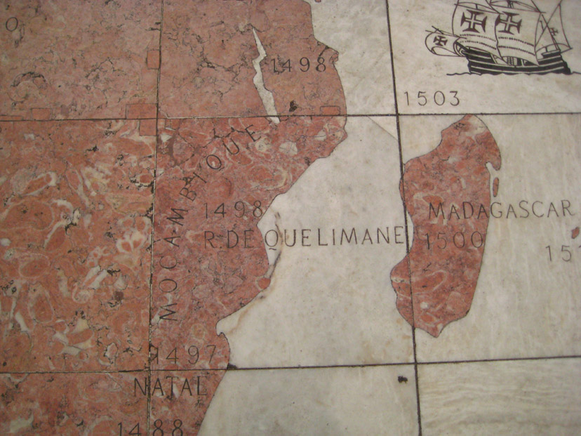
There is a large plaza with an inlaid map of the Portuguese voyages of discovery (more details below) and, opposite the square and across the Avenida de Brasilia motorway, is the Square of the Empire and behind that the Jeronimos Monastery, Belem Cultural Center and the green-spaces of the Garden Vasca da Gama (you can see a picture of these features, taken through the green-tinted bus window here).
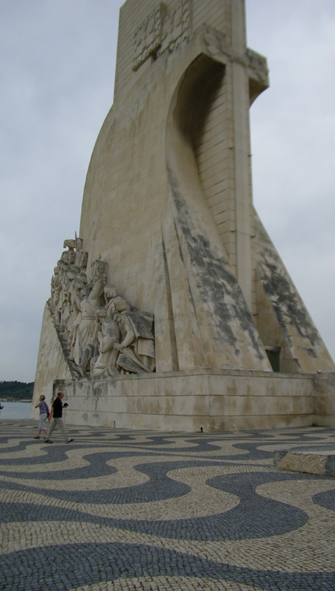
The monument itself is a 171-foot high slab taking the form of the prow of a caravel (ship used in the early Portuguese exploration). On either side of the slab are ramps that join at the river's edge, with the figure of Henry the Navigator at the top overlooking the estuary.
On either side of Henry, and behind him on each ramp, are 16 figures (different on each side) representing figures from the Portuguese Age of Discovery. These great people of the era included monarchs, explorers, cartographers, artists, scientists and missionaries. Each idealized figure is designed to show movement towards the front (the unknown sea), projecting a direct or indirect synthesis of their participation in the events after Henry.
There is an interior space that we didn't have time to go into. There is an auditorium with space for 100 people, exhibition halls and four multipurpose rooms. Normally, the auditorium hosts a multimedia exhibition on the history of Lisbon. The top of the monument (reached via an elevator or stairs) offers views of the Tagus river, the Belém neighborhood and its many attractions, including the Belém Tower and the Jerónimos Monastery, which date from the Age of Discovery.
The two aspects of the Monument that are of the most interest are the carved figures on the Monument itself, and the "compass rose" in the square in front of it.
I thought the sculpted figures were pretty amazing, although I didn't realize at the time that there were groups of figures on both sides of the Monument. I just never got around to the eastern side (although Fred did and you can see a picture of the figures on that side here). On the west side I found that I had to get back so far to get them all in that each figure was quite small, and I lost a lot of detail. You can see some of this detail in the picture Fred took at left of the bottom three figures from the west side of the Monument. From left to right, these figures are Prince Peter, Duke of Coimbra (son of King John I of Portugal), Queen Philippa of Lancaster (mother of Henry the Navigator) and Fernão Mendes Pinto (explorer and writer).
Fred took some additional pictures of the sculpted figures in closeup, and one from the bus of the entry to the inside of the Monument. Click on the thumbnails below to have a look at these pictures:
So what I thought I'd try to do would be to photograph the frieze in sections, and then put the sections together later. The result was quite acceptable, although it would have been better had I been able to get closer to the frieze and take more pictures. Anyway, you can have a look at the result below:
Of course, you probably know who all these folks are, but just in case you don't, here they are, all nicely identified:
In case you are interested in who these folks are, here is a brief description of each:
Prince Peter, Duke of Coimbra
Henry the Navigator's brother, and the most well-travelled prince of his time
Queen Philippa of Lancaster
Mother of Henry the Navigator
Fernão Mendes Pinto
Explorer and writer
Friar Gonçalo de Carvalho
Spiritual advisor
Friar Henrique Carvalho
Spiritual advisor
Luís de Camões
Renaissance poet who celebrated the navigations in the epic Lusiads
“Forte de Santo António da Cruz”, também referido como "Forte da Cruz de Santo António" e “Forte da Cruz da Subida”, localizava-se na freguesia de União das Freguesias de Cascais e Estoril, concelho de Cascais, distrito de Lisboa, em Portugal.
Foi edificado no contexto da Guerra da Restauração da independência portuguesa (1640-1668), integrando a 1.ª linha de fortificações da barra do Tejo, que se estendia do cabo da Roca até à Torre de Belém para defesa da cidade de Lisboa. Na extremidade oeste da praia de Santo António (atual praia do Tamariz), cruzava fogos com o Forte de São Pedro do Estoril, a oeste.
História
Foi erguido na década de 1640 por determinação do Conselho de Guerra de João IV de Portugal (1640-1656), sob a supervisão do Governador das Armas da Praça de Cascais, D. António Luís de Meneses (1642-1675), 3° conde de Cantanhede. Tendo existido uma cruz no terreiro desse forte, terá sido essa a razão de sua designação.
Perdida a sua função militar em fins do século XIX, foi adquirido por um particular. COLAÇO e ARCHER (1943) informam que “pelo ano de 1886” um “rico capitalista lisboeta, de seu nome João Martins de Barros, foi habitar, em São João do Estoril, uma casa em frente da Poça”. “Adoecera-lhe uma filha e esperava vê-la curada pelo ar do pinhal e do mar”, nas Termas da Poça, de anemia crónica, o que veio a acontecer, dispondo-se o pai a “fazer uma casa no local onde se operara a maravilha”. Não a podendo construir junto à praia da Poça, escolheu “para ela um poiso deslumbrante”, um pouco mais à frente na linha de costa: o “antigo forte de Santo António do Estoril, muralhas quasi ruídas, mas ainda alcandoradas sobre os rochedos que afloram, à esquerda de quem olha o mar, no areal do Estoril”. Adquirido o imóvel ao Estado (1894), aí nasceria um palacete em estilo neomedieval (1895), sob o risco do arquiteto italiano Cesar Ianz, um dos pioneiros da arquitetura de veraneio de Cascais. Ianz ficou arruinado com a construção, adjudicada por um valor que calculou mal, mas cumpriu o contrato. O imóvel ficou conhecido como “Chalet Barros”, hoje “Palácio Barros”.
Atualmente de propriedade de Miguel de Polignac Mascarenhas de Barros, embaixador da Ordem Soberana de Malta em Portugal, o imóvel conheceu processo de recuperação, restauro e remodelação. Ostenta a bandeira da Ordem de Malta como residência oficial do embaixador.
Bibliografia
COLAÇO, Branca de Gonta; ARCHER, Maria. “Memórias da Linha de Cascais”. 1943.
12 de mar. de 2018 - Rua Luís de Camões, 63, r/c - D. 2460-014 ... Arouca. Rua Dr. António Casimiro Leão Pimentel ... Casa do Combatente – Beco do Paiol, 32-A ... Av.ª Dr. José Catanho Meneses, ... da praia de Santo António do Estoril, se deram conta de terem estado num dos antigos pontos fortificados da Linha de Defesa.
12 de mar. de 2018 - Rua Fonte Nova, 2 - Estrada Nacional 371. 7370-201 ... Casa do Combatente – Beco do Paiol, 32-A ... OTenente-general Vaz Antunes, atual Chefe da Casa Militar da Pre- ... Torre do Tombo. ... Revista «Branco e Negro, nº 31 de NOV 1896; ... Livro Grandezas de Lisboa, de Frei Nicolau de Oliveira,1620.
Forte de Santo António da Barra / Fortaleza de Santo António
IPA.00006072
Portugal, Lisboa, Cascais, União das freguesias de Cascais e Estoril
Arquitectura militar, moderna abaluartada. Forte costeiro quinhentista para defesa marítima integrado no programa filipino de fortificação da barra do Tejo com o contributo de engenheiros militares italianos, constituindo uma das fortificações desenhadas por Vicenzo Casale na última década do século 16, integrando alteração proposta por Leonardo Turriano. Incluído na rede de fortificação costeira do século 17 desenvolvida no contexto da Restauração. Fortificação de planta quadrangular, composta por dois baluartes virados a terra e por dois meios baluartes virados ao mar, formando flancos e cortinas muito curtos; integra fosso seco com estrada coberta, praça baixa com bateria, bateria alta e conjunto edificado destinado a quartéis, casa do governador e armazéns de artilharia. Constitui o mais importante ponto intermédio da defesa costeira entre a Fortaleza de São Julião da Barra e a Fortaleza de Nossa Senhora da Luz / Cidadela de Cascais, assim pensado desde o século 16 e em complemento com o Forte de São Lourenço da Cabeça Seca / Bugio, este projectado também por Vicenzo Casale. No século 17 e no contexto da Restauração este sistema de defesa marítima foi reforçado com fortins, baterias e linhas de fuzilaria complementares às fortificações principais. Fortificação quase regular, apesar de adaptada à morfologia do terreno muito irregular no lado marítimo, facto que terá justificado a alteração proposta por Leonardo Turriano, passando a incluir duas baterias a cobrir o lado costeiro. Adaptação contemporânea para fins residenciais e recreativos no contexto institucional do Ministério da Defesa.
Número IPA Antigo: PT031105040013
Registo visualizado 2141 vezes desde 27 Julho de 2011
Fortificação abaluartada de planta quadrangular, composta por dois baluartes virados a terra (NO. e NE.) e por dois meios baluartes virados para o mar (SO. e SE.), com três dos ângulos flanqueados iguais, mas formando flancos e cortinas muito curtos. A frente voltada ao mar é a mais irregular devido ao facto de integrar uma praça com bateria baixa e uma bateria alta com acesso ao aquartelamento. O recinto magistral, circundado por cordão, apresenta paramentos em talude, em cantaria aparente apenas nas faces voltadas ao mar e nos cunhais, sendo os restantes panos rebocados, tal como os parapeitos que incluem actualmente apenas três canhoneiras; integra oito guaritas cilíndricas (revestidas por cimento) com cobertura em cúpula e rematadas com um pináculo, quatro inseridas no recinto magistral e quatro nos ângulos da contra-escarpa do fosso; apenas uma das guaritas (SE.), de construção contemporânea, apresenta forma octogonal. O fosso é seco (à excepção do lado costeiro) e inclui contra-escarpa com estrada coberta e correspondente banqueta; o fosso comunica com o mar no lado SO., enquanto no lado SE. é cortado pela entrada do forte, constituindo a zona mais irregular que foi objecto de alteração da estrutura quinhentista inicial. O acesso efectua-se a partir do fosso, através de ponte (antes levadiça e junto à zona ocupada com corpo da garagem e anexo), incluindo trânsito com corpo da guarda, isto é, um túnel que dá acesso à praça e bateria baixa, integrando ainda um lanço de escadas para subir à bateria alta (erguida sobre o corpo da guarda) e ao quartel. A praça baixa incorpora o parapeito da bateria, o acesso à cisterna de água nativa, a quatro compartimentos correspondentes à Casa do Governador, assim como aos armazéns, marcados por duas arcadas sob o meio baluarte SO., actualmente fechadas mas integrando portas de lintel recto encimadas por duas janelas. O aquartelamento superior apresenta planta rectangular desenvolvendo três pisos, sendo dividido em duas alas também rectangulares, comunicando entre si através de uma corredor com pé-direito total marcado por arco de volta inteira em cantaria e coberto com abóbada de berço, ao fundo do qual se encontra a capela. Cada um dos blocos inclui quatro portas de acesso aos dois primeiros pisos, integrando compartimentos que serviam de quartel para os soldados e de armazéns de artilharia; a partir do espaço aberto entre os baluartes e o quartel efectua-se a entrada para o terceiro piso, de pé direito menor e com cobertura plana. A capela dedicada a três padroeiros (Santo António do Estoril, Santa Bárbara e Nossa Senhora do Socorro), de pequena dimensão, tem planta rectangular e apresenta portal de lintel recto em mármore encimado por pequeno nicho caiado com imagem de Santo António; interior coberto com abóbada de berço rebocada, apresentando estrutura do retábulo-mor em mármore, com arco de volta inteira enquadrado por pilastras molduradas e encimado por frontão triangular com base ornamentada alternadamente por medalhões ovais e losangos; interior com abóbada de berço e mesa de altar também paralelepipédico, em mármore e com frontal decorado por losangos. O conjunto dos espaços integra em várias zonas azulejos policromos do Estado Novo, em silhares e painéis representando momentos heróicos da História de Portugal.
Acessos
São João do Estoril; Avenida Marginal
Protecção
Categoria: IIP - Imóvel de Interesse Público, Decreto n.º 129/77, DR, 1.ª série, n.º 226 de 29 setembro 1977
Enquadramento
Urbano, marítimo. Enquadrado no núcleo urbano de São João do Estoril, situa-se entre a zona costeira rochosa e a zona arborizada da Avenida Marginal. Parte integrante da Área Metropolitana de Lisboa, o forte localiza-se na entrada da barra do Tejo, na margem direita da sua foz, aproximadamente à cota altimétrica de 25 m, marcando o início da baía de Cascais. A O. encontra-se o núcleo urbano do Estoril, marcado ainda por duas fortificações costeiras. Constitui o principal ponto de defesa entre o Forte de Nossa Senhora da Luz de Cascais (v. IPA.00006052) e o Forte de São Julião da Barra em Oeiras (v. IPA.00002343).
Descrição Complementar
Utilização Inicial
Militar: forte
Utilização Actual
Assistencial: colónia de férias
Propriedade
Pública: estatal
Afectação
Ministério da Defesa Nacional - Exército
Época Construção
Séc. 16 / 17
Arquitecto / Construtor / Autor
ENGENHEIROS MILITARES: Alexandre Massai (1617); Leonardo Turriano (1600); Mateus de Couto (1693); Maximiano José da Serra (1796); Vicenzo Casale (1589).
Cronologia
1580, agosto - desembarque em Cascais das tropas comandadas pelo Duque de Alba, cuja celeridade da marcha em direcção a Lisboa demonstrou a fragilidade da linha defensiva da barra do Tejo; 1589, 23 dezembro - carta do engenheiro Giovanni Vicenzo Casale e do capitão Fernando da Costa, dirigida ao rei Filipe I de Portugal, afirmando que já estava escolhido o local para a construção de um forte, apresentando os planos da edificação e justificando que um pequeno forte seria suficiente, dado que se estava a fortificar a Cabeça Seca; a proposta (não construída) referia-se a um torreão de 100 pés, de forma quadrangular, utilizando taipa como principal material construtivo, revestindo-o de madeira de forma a sustentar o terrapleno e, para protecção das águas do mar, uma fina camada de alvenaria ou de tijolo; o forte deveria ser reforçado com uma linha de mosquetaria, na qual se disporiam quatro peças de artilharia, que bateriam fogo sobre as enseadas limítrofes (Massai, 1621, fol. 96); 1590, 10 fevereiro - carta régia autorizando a construção do forte; todavia, nesse mesmo ano e antes de receber tal autorização, Casale apresentou ao rei nova proposta com a ampliação da forte enviando-lhe dois desenhos, um referente à implantação na costa e outro com planos para um forte de traçado quadrangular com quatro baluartes regulares, incluindo fosso, bateria baixa e ao centro quartéis para soldados (Massai, 1621, fol. 97), correspondendo no essencial à estrutura que foi construída; nesse mesmo ano, Frei Vicenzo Casale tinha também a seu cargo a ampliação da Torre de São Vicente ou de Belém (v. IPA.00004065) e a construção da Torre de São Lourenço ou Torre do Bugio (v. IPA.00006548); 1591, 16 fevereiro - Casale informava o monarca que o forte estava apto a receber "gente e artilharia", uma vez que as obras que faltavam eram somente na zona exterior da fortificação; 1600 - relatório de Leonardo Turriano assinala ser indispensável a reparação dos parapeitos, propondo ainda a construção de uma praça alta sobre os quartéis para aumentar o poder de fogo, alterações essas efectuadas em data indeterminada; 1617 - desenho de Alexandre Massai, assinalando que "no fabricar delle se mudou alguas cousas" (Massai, 1621, fol. 88), talvez reflectindo as alterações propostas por Turriano e que identificam em levantamentos posteriores; 1642, 6 fevereiro - relatório de D. António Luís de Meneses, responsável pelo aparelho defensivo da Barra do Tejo, refere o mau estado de conservação do forte (DGARQ/TT, CG, Consultas, m. 2, n.º 5); 1644, 12 Agosto - a ponte levadiça e a cancela encontravam-se em ruína, apesar do forte se encontrar artilhado (DGARQ/TT, CG, Consultas, cx. 11, m. 4, n.º 317); 1681- a guarnição do forte ainda se encontrava activa (Ramalho, Boiça e Barros, 2001, p. 128); 1693 - levantamento da planta do forte por Mateus do Couto (DGARQ/TT); 1720, 29 Junho - relatório do coronel João Xavier Teles refere obras de reparação nas casas, quartéis e armazéns, encontrando-se a fortificação em bom estado (Biblioteca Pública de Évora, Cx. 2-15, n.º 1); 1735, 31 março - o forte encontrava-se já em estado de degradação, sendo necessário efectuar obras nas baterias e nas casas do governador, do tenente e do capelão (Relação das Fortalezas e Fortes de toda a Marinha da Estremadura, BNP, Cod. 421); 1735, cerca - entaipamento da arcaria da praça de armas; 1762 / 1763 - campanha de obras na maior parte dos fortes da Barra de Cascais, onde se terá incluído este mesmo forte, devido a medidas de prevenção no contexto da Guerra dos Sete Anos; 1777 - o forte encontrava-se em razoáveis condições, mas a casa do corpo da guarda estava destelhada, os quartéis com soalhos em mau estado e faltava uma porta no paiol da bateria baixa; 1796 - planta atribuível Maximiano José da Serra (BPMP, GEAEM/DIE), referindo as obras executadas pelo capitão José Francisco António Dias e existência de peças de artilharia; 1831, 11 Julho - forçamento da barra do Tejo pela esquadra francesa comandada pelo almirante Roussin, quando o forte não tinha qualquer peça de artilharia, uma vez que se encontrava em obras; 1831 /1832 - no contexto das Lutas Liberais o forte sofreu intervenções nos alojamentos (rebocos, portas, soalhos), no paiol da pólvora (telhado e interior), muralhas e parapeito da estrada coberta junto à contra-escarpa do fosso; recolocação das Reais Armas Portuguesas sobre a porta do forte, restituição de guarnição e artilharia; 1832 - o forte tinha ao serviço um governador, dois subalternos de artilharia, um cabo e seis soldados de milícias e seis peças de artilharia; 1886 - relatório de inspecção registou o mau estado de conservação pelo facto do forte estar inactivo, encontrando-se somente as muralhas em bom estado; 1889 - instalação de um Posto da Guarda Fiscal para evitar o contrabando de mercadorias, que pouco tempo depois foi transferido provisoriamente para um edifício próximo; séc. 19, fins / séc. 20, inícios - campanha de obras de adaptação a novas funções; embora estivesse na lista de Praças de Guerra Desclassificadas da 1ª Divisão continuou a manter o destacamento de um governador; 1915 - morte do coronel José Ribeiro Júnior, último oficial com o cargo de Governador do Forte de Santo António da Barra, passando então a funcionar como colónia de férias do Instituto Feminino de Educação e Trabalho de Odivelas; 1962 - funcionamento como colónia de férias do Instituto de Odivelas; 1968, 08 agosto - adaptação do forte para residência sazonal do Presidente do Conselho António Oliveira Salazar, local onde sofreu uma queda de cadeira que levou à sua morte pouco tempo depois; 2018, 17 abril - é publicada a Resolução da Assembleia da República n.º 113/2018 (DR n.º 75/2018, 1.ª série), que recomenda ao Governo que assegure com urgência a proteção e recuperação do Forte de Santo António da Barra.
Dados Técnicos
Estrutura de paredes portantes.
Materiais
Calcário, alvenaria de pedra, cimento, ferro, madeira, telha, azulejo.
Bibliografia
BOIÇA, Joaquim Manuel Ferreira - A Barra do Tejo. O eixo São Julião-Bugio. Navegabilidade, Defesa e Alumiamento. Oeiras: Câmara Municipal de Oeiras, 2000; CARDOSO, Luís - Diccionario Geografico... Lisboa: Regia Officina Sylviana, 1747, tomo I; GODINHO, Helena Campos, MACEDO, Silvana Costa, PEREIRA, Teresa Marçal - "Levantamento do Património do Concelho de Cascais. 1975 - Herança do Património Arquitectónico Europeu", in Arquivo de Cascais, 1990, nº 9; GÓIS, Damião de, trad. Aires A. Nascimento - Elogio da cidade de Lisboa. Lisboa: Guimarães Editores, 2002; GUEDES, Lívio da Costa - Aspectos do Reino do Algarve nos séculos XVI e XVII: a descripção de Alexandre Massaii (1621). Lisboa: Arquivo Histórico Militar, 1989; LOURENÇO, Manuel Acácio Pereira - As fortalezas da costa marítima de Cascais. Cascais: Câmara Municipal, 1964; Ministério das Obras Públicas - Relatório da Actividade do Ministério no ano de 1954. Lisboa: 1955; MOREIRA, Rafael - "A arquitectura militar do Renascimento em Portugal", in A Introdução da Arte da Renascença na Península Ibérica. Coimbra: Epartur - Instituto de História da Arte da Universidade de Coimbra, 1981, pp. 281-305; MOREIRA, Rafael - "Do Rigor Teórico à Urgência Prática: a Arquitectura Militar", in História da Arte em Portugal. Lisboa: Publicações Alfa, 1986, vol 8; RAMALHO, Margarida de Magalhães; BOIÇA, Joaquim Manuel Ferreira; BARROS, Maria de Fátima Rombouts de - As fortificações marítimas da costa de Cascais. Lisboa: Quetzal - Câmara Municipal de Cascais, 2001.
Documentação Gráfica
IHRU/SIPA, DGEMN:DRMLisboa, Doc. 37738, DGEMN: DSID-001/011-1209; BPMP: planta do Forte de Santa António da Barra, Maximiano José da Serra,1796 (Plantas dos fortes e fortalezas da costa do norte do Reino de Portugal, Cod. 49, cópia GEAEM/DIE 8100-3-43); DGARQ/TT: Casa Cadaval, livro 29, fl. 81, planta do forte de Santo António, Mateus do Couto, 1693; CML, Museu da Cidade: projecto da Fortaleza de Santo António da Barra, Vicenzo Casale, 1590 (Alexandre Massai, Descripção do Reino de Portugal, 1621).
Documentação Fotográfica
IHRU/SIPA; DGEMN / DSID e DSARH
Documentação Administrativa
IHRU/SIPA; DGEMN / DSID e DSARH; Arquivo Geral da Marinha: Mapa da Fortaleza de Santo António da Barra, 1779 (1-10-4, Cx. 307); Biblioteca Pública de Évora: Relatório do Coronel João Xavier Teles, Conde de Unhão, 29 Junho 1720 (Cx. 2-15, nº 1); BNP: Relação das Fortalezas e Fortes de toda a Marinha da Estremadura, 31 Março 1735 (Cod. 421); CML, Museu da Cidade: Alexandre Massai, Descripção do Reino de Portugal, 1621, fol.s 96-97 ; DGARQ/TT: Relatório, 12 Agosto 1644 (CG, Consultas cx. 11, m. 4, n.º 317), Carta de D. António Luís de Meneses, 6 Fevereiro 1642 (CG, Consultas, m. 2, doc. 5); Mapa de guarnição, 16 Abril 1762 (Ministério do Reino, m. 620); GEAEM / DIE: Relatório do Brigadeiro José G. F. Passos e do Capitão Engenheiro Joaquim A. E. Vaz, 26 Março 1854 (3130-6-83-118).
Intervenção Realizada
DGEMN: 1954 - construção de uma garagem na residência de verão do Presidente do Conselho; trabalhos de acesso à garagem; regularização dos terrenos; 1960 - colocação de instalação eléctrica.
Observações
O Forte de Santo António da Barra não deve ser confundido com o desaparecido Forte de Santo António do Estoril que se localizava na praia do Tamariz (v. Plantas dos fortes e fortalezas da costa do norte do Reino de Portugal, 1796, BPMP, Cod. 49, cópia GEAEM/DIE 8100-3-43). Descrição do Forte de Santo António em 1854: "Este Forte é um quadrado fortificado por meio do sistema abaluartado com flancos e cortinas muito curtos e perfeitamente regular nos lados Leste, Norte e Oeste sendo por estes lados circundando de um fosso e de uma entrada coberta e competente esplanada. Os seus parapeitos de 8,5 palmos de grossura pouco mais ou menos são de alvenaria com canhoneiras podendo nos lados de Leste e Oeste 4 bocas-de-fogo. Na frente Leste próximo da face do Baluarte existe um paiol e casa para balame, cobertos por telhado, que, necessitam de alguns consertos. A frente do Sul é irregular constando de duas baterias, superior e inferior, a primeira fornada de um parapeito a barbete de 4,5 palmos de altura e 5 de espessura. Pode conter 3 bocas-de-fogo e a segunda feita do mesmo modo e aproximadamente de iguais dimensões, pode assestar 8, sendo colocadas 2 no estreito do plano do fosso com frente a Oeste e 1 na outra extremidade fronteira a Leste. No centro da fortificação se eleva um terraço fechado de abobada de 87 palmos de comprimento por 72 de largura para o qual assim como para a bateria superior dá acesso uma escada de bastante declive e estreitos degraus o que torna muito dificultoso o transporte de Artilharia para aqueles pontos. E por baixo deste terraço existe o espaçoso quartel do Governador, casa de palamenta, bons armazéns, arrecadações e outros alojamentos que podem alguns deles servir de paiões quando as circunstâncias o exigirem por serem à prova e secos, ficando os quartéis de guarnição por baixo da bateria superior nos quais e em alguns dos alojamentos referidos podem acomodar de 80 a 100 praças. Existe no plano da bateria baixa uma boa cisterna talhada em rocha com água nativa e no mesmo plano uma casa de trânsito fechada de abobada, para serventia do Forte, onde há comodo para alojar a guarda da porta, e junto à qual mostra ter havido ponte levadiça. Diversos lugares da fortificação carecem de alguns reparos, principalmente a muralha para o lado do mar, o quartel do Governador, quarteis de guarnição e paiol. A sua elevação sobre o nível do mar é de 63 palmos proximadamente. Ignora-se a época em que foi construído, depreendendo-se, porém, pela sua configuração e informações obtidas, que já existia no Reinado dos três Filipes de Castela." Relatório do brigadeiro José G. F. Passos e do capitão engenheiro Joaquim A. E. Vaz, 26 Março 1854 (GEAEM/DIE,3130-6-83-118).
Licença: Domínio Público (Autor falecido há mais de 70 anos). - Data: 1910
Iconografias > Forte de Santo António da Cruz - 004255 Chalet Barros no Estoril (Portugal). Postal n.º 1785, Lisboa, Edição Costa, c. 1905.
Licença: Domínio Público (Autor falecido há mais de 70 anos). - Data: 1905
O “Forte de Santo António da Cruz”, também referido como "Forte da Cruz de Santo António" e “Forte da Cruz da Subida”, localizava-se na freguesia de União das Freguesias de Cascais e Estoril, concelho de Cascais, distrito de Lisboa, em Portugal.
Foi edificado no contexto da Guerra da Restauração da independência portuguesa (1640-1668), integrando a 1.ª linha de fortificações da barra do Tejo, que se estendia do cabo da Roca até à Torre de Belém para defesa da cidade de Lisboa. Na extremidade oeste da praia de Santo António (atual praia do Tamariz), cruzava fogos com o Forte de São Pedro do Estoril, a oeste.
História
Foi erguido na década de 1640 por determinação do Conselho de Guerra de João IV de Portugal (1640-1656), sob a supervisão do Governador das Armas da Praça de Cascais, D. António Luís de Meneses (1642-1675), 3° conde de Cantanhede. Tendo existido uma cruz no terreiro desse forte, terá sido essa a razão de sua designação.
Perdida a sua função militar em fins do século XIX, foi adquirido por um particular. COLAÇO e ARCHER (1943) informam que “pelo ano de 1886” um “rico capitalista lisboeta, de seu nome João Martins de Barros, foi habitar, em São João do Estoril, uma casa em frente da Poça”. “Adoecera-lhe uma filha e esperava vê-la curada pelo ar do pinhal e do mar”, nas Termas da Poça, de anemia crónica, o que veio a acontecer, dispondo-se o pai a “fazer uma casa no local onde se operara a maravilha”. Não a podendo construir junto à praia da Poça, escolheu “para ela um poiso deslumbrante”, um pouco mais à frente na linha de costa: o “antigo forte de Santo António do Estoril, muralhas quasi ruídas, mas ainda alcandoradas sobre os rochedos que afloram, à esquerda de quem olha o mar, no areal do Estoril”. Adquirido o imóvel ao Estado (1894), aí nasceria um palacete em estilo neomedieval (1895), sob o risco do arquiteto italiano Cesar Ianz, um dos pioneiros da arquitetura de veraneio de Cascais. Ianz ficou arruinado com a construção, adjudicada por um valor que calculou mal, mas cumpriu o contrato. O imóvel ficou conhecido como “Chalet Barros”, hoje “Palácio Barros”.
Atualmente de propriedade de Miguel de Polignac Mascarenhas de Barros, embaixador da Ordem Soberana de Malta em Portugal, o imóvel conheceu processo de recuperação, restauro e remodelação. Ostenta a bandeira da Ordem de Malta como residência oficial do embaixador.
Bibliografia
COLAÇO, Branca de Gonta; ARCHER, Maria. “Memórias da Linha de Cascais”. 1943.


