🌹🌹🌹💞🌌Rosa dos Ventos 🌌💞🌹🌹🌹

▼

quinta-feira, 26 de maio de 2022

Lapa Paraná "Emygdio Westphalen" Ano 1908\Edição A00065 (2) pagina 3116 de 3498/ Paraná / Hotpage/HotpageBN.aspx?

 Ano 1908\Edição A00065 (2) pagina 3116 de 3498


http://memoria.bn.br/DocReader/Hotpage/HotpageBN.aspx?bib=313394&pagfis=84133&url=http://memoria.bn.br/docreader#


Nasceu na Vila Nova do Príncipe, atual Lapa, Paraná, em 11 de janeiro de 1847, filho de Eugênio Westphalen e Joanna Francisca Westphalen. Casou-se com Joaquina de Paula Xavier, em 14 agosto de 1870, com quem teve as filhas Eudoxia e Elvira. Após tornar-se viúvo, contraiu núpcias com Januária Carvalho de Oliveira, em 10 de dezembro de 1877.

Em São Paulo, iniciou seus estudos secundários e diplomou-se em Direito pela Faculdade de Direito no Largo de São Francisco (1867). Foi um dos fundadores da Loja Maçônica Fraternidade Paranaense, em Curitiba (1897). Participou da imprensa da época, defendendo um governo democrático no país, e colaborou com os jornais “Opinião Liberal”, “Commércio de Paranaguá”, “Livre Paraná”, “d'A Reforma”,  “Província do Paraná”,  “Dezenove de Dezembro” (Curitiba), “Correio Nacional” e o “Fluminense” (Rio de Janeiro).

Iniciou sua vida profissional como promotor público em Paraíba do Sul, no Rio de Janeiro. Mais tarde, voltou ao Paraná, atuou nos cargos de promotor e vereador na Lapa, onde também exerceu a advocacia e o cargo de inspetor literário, criando a Associação Literária Lapeana. Destacou-se no judiciário paranaense como juiz municipal de Curitiba e juiz de Direito da Comarca da Lapa (1890). Nomeado chefe da polícia do Estado do Paraná em 19 de dezembro de 1890. Foi vereador e presidente da Câmara Municipal de Curitiba. Em 1º de agosto de 1891, no período de instalação do regime republicano constitucional, foi nomeado desembargador do Tribunal do Estado do Paraná. Porém, devido às suas convicções liberais na política e por sua alegada participação na Revolução Federalista (1893–1895), foi perseguido e, por consequência, exilou-se na Argentina, voltando ao Brasil após a anistia assinada pelo Presidente Prudente de Moraes (1894-1898).

Nomeado ao cargo de procurador geral da justiça do Estado em 27 de abril de 1908, exerceu as funções até 17 de fevereiro de 1912. ¹


VILLA NOVA DO PRÍNCIPE, LAPA, PARANÁ BRASIL, Vila Nova do Princípe, Lapa, ///PR. Cidade de;


procurando "Santo Antonio da Lapa"

http://memoria.bn.br/DocReader/Hotpage/HotpageBN.aspx?bib=313394&pagfis=84133&url=http://memoria.bn.br/docreader#

Ano 1900\Edição A00057 (1)

página 710 no primeiro quadrado de 1433


///////////////////////////////////////


Ano 1903\Edição A00060 (2)


1165de 1629


///////////////////////////////////////


Ano 1907\Edição A00064 (1)  2051 de 2399
às maio 26, 2022
Compartilhar

sexta-feira, 6 de maio de 2022

S Em, G W que filme que eu peguei isto?

 G Gravidade S Em = Eletromagnetismo W potência , rs! é uma bateria mesmo, não tem fim. Fora o livro mãos de luz que explica tudo isso aí e eu pra variar não entendi nada.

O meu nome me parece sempre é um letreiro tentando ensinar alguma coisa. Mas está difícil. O recado tá alí, mas eu entendi? não né mané!
Teoria do Tudo Todo. Universo Elegante, seja elegante.

O eletromagnetismo é muito mais forte que a gravidade como?
se passa a quarta coordenada porque se quebrou o eletromagnetísmo? e como faz isso?

às maio 06, 2022
Compartilhar

segunda-feira, 2 de maio de 2022

Atlas de Joan Martines

Title
Atlas of Joan Martines.
Other Title
Atlas de Joan Martines
Summary
This manuscript atlas by Joan Martines, cosmographer to King Philip II of Spain, dated 1587, represents the combination of two cartographic schools that existed at the time of its creation. The older one was the traditional school of Majorca, which specialized in decorative portolan maps that by this time were obsolete with regard to the geographic information they conveyed. The newer one was the cartographic school of the Low Countries, which applied Renaissance principles and used different forms of cartographic representation based on new concepts in astronomy, mathematics, and geography to produce maps containing more information than the traditional portolans. The atlas consists of 19 maps, each on two pages, with the drawings occupying nearly the length of the pages and framed by edgings of different colors. Place-names are given in Gothic letters, in red and black ink, and in Roman small capitals. There are six nautical charts, 11 regional maps, and two maps of the world, all luxuriously illuminated in colored-wash drawing, with panes of gold and silver. Most of the maps have a large compass rose showing 16 or 32 directions, and some of the maps depict ships sailing the seas.
Contributor Names
Martines, Joan, 1556--1590 Cartographer.
Created / Published
[place of publication not identified] : [publisher not identified], 1587.
Subject Headings
-  1587
-  Illuminations
-  Manuscript maps
-  Nautical charts
-  Portolan charts
-  World maps


http://worldcat.org/identities/lccn-n99033530/

Atlas de Joan Martines, 1587 by Joan Martines( Book )


21 editions published between 1587 and 2000 in 4 languages and held by 45 WorldCat member libraries worldwide

Spanish:  Este atlas manuscrito de Joan Martines, cosmógrafo del rey Felipe II de España, fechado en 1587, representa la combinación de dos escuelas cartográficas que existían al momento de su creación. La más antigua era la escuela tradicional de Mallorca, especializada en mapas portuláneos decorativos que por esa época eran obsoletas con respecto a la información geográfica que transmitían. La más reciente era la escuela cartográfica de los Países Bajos, que aplicaba los principios del Renacimiento y utilizaba diferentes formas de representación cartográfica, sobre la base de nuevos conceptos en astronomía, matemática y geografía, para producir mapas que contenían más información que los portuláneos tradicionales. El atlas consta de 19 mapas, cada uno en dos páginas, con los dibujos que ocupan casi la longitud de las páginas y están enmarcados por ribetes de colores diferentes. Los topónimos están en letra gótica, en tinta roja y negra, y en pequeñas mayúsculas romanas. Hay seis cartas náuticas, 11 mapas regionales y dos mapas del mundo, todos lujosamente iluminados a la aguada, con áreas de oro y plata. La mayoría de los mapas tienen una gran rosa de los vientos que indica 16 o 32 direcciones, y algunos de los mapas muestran barcos que navegan los mares.  English:  This manuscript atlas by Joan Martines, cosmographer to King Philip II of Spain, dated 1587, represents the combination of two cartographic schools that existed at the time of its creation. The older one was the traditional school of Majorca, which specialized in decorative portolan maps that by this time were obsolete with regard to the geographic information they conveyed. The newer one was the cartographic school of the Low Countries, which applied Renaissance principles and used different forms of cartographic representation based on new concepts in astronomy, mathematics, and geography to produce maps containing more information than the traditional portolans. The atlas consists of 19 maps, each on two pages, with the drawings occupying nearly the length of the pages and framed by edgings of different colors. Place-names are given in Gothic letters, in red and black ink, and in Roman small capitals. There are six nautical charts, 11 regional maps, and two maps of the world, all luxuriously illuminated in colored-wash drawing, with panes of gold and silver. Most of the maps have a large compass rose showing 16 or 32 directions, and some of the maps depict ships sailing the seas
Portolan atlas Joan Martines en Messina, añy 1582; facsimile, with introduction by Edward Luther Stevenson by Joan Martines( )

1 edition published in 1915 in English and held by 23 WorldCat member libraries worldwide

[Manuscript portolan atlas of the world] [cartographic material] : by Joan Martines( )

1 edition published in 2018 in English and held by 20 WorldCat member libraries worldwide

Description: Chart of north-western Africa, southwestern Spain, and the Canary Islands, Chart of the coast of Africa between Mauritania and the Cape of Good Hope, Chart of the British Isles, western Europe, western Mediterranean Sea, and north-western Africa, Chart of the eastern Mediterranean Sea and the Black Sea. Verso of last chart includes annotation tracing previous ownership, including 1595 inscription signed "W.L. Burghly " noting that he was given the atlas by Charles Howard, Earl of Nottingham and chief English admiral during the Spanish Armada of 1588. Inscription, apparently by Pierre Esprit Radisson, French explorer and fur trader in North America, noting that the atlas was given to him by Charles Bayley, first governor of Hudson's Bay. Inscription by "Morpin " noting that Radisson gave him the atlas in 1675 and note, also by Morpin, stating he returned the atlas to Radisson
Portolan atlas, Joan Martines en Messina añy 1582 by Joan Martines( Book )

4 editions published in 1915 in English and Spanish and held by 8 WorldCat member libraries worldwide

[Amèrica del Sud] by Joan Martines( )

3 editions published between 1587 and 1973 in Spanish and Italian and held by 4 WorldCat member libraries worldwide

[Àfrica] by Joan Martines( )

3 editions published in 1973 in Latin and Spanish and held by 4 WorldCat member libraries worldwide

[Map of the west coast of Mexico, the New Mexican area, the California peninsula, and Japan] by Joan Martines( )

3 editions published between 1956 and 1957 in Italian and held by 4 WorldCat member libraries worldwide

Typus orbis terrarum by Joan Martines( )

4 editions published between 1587 and 1973 in Latin and held by 4 WorldCat member libraries worldwide

 
moreShow More Titles
Audience Level
0
Audience Level
1
 General
Special 
Audience level: 0.72 (from 0.46 for [A Map of ... to 0.99 for [Carta por ...)

WorldCat IdentitiesRelated Identities
  • Oliva, Joan active 1580-1615 Other plus
  • Wolter, John Amadeus 1925- Other plus
  • Stevenson, Edward Luther 1858-1944 Cartographer plus
  • España Dirección General de Archivos y Bibliotecas plus
  • Spain Dirección General de Archivos y Bibliotecas Other plus
  • Sánchez Beldo, Luis plus
  • Adam Matthew Digital (Firm) plus
  • Spain Ministerio de Educación y Ciencia plus
  • Ibáñez Cerdá, José Author of introduction plus
  • Sánchez Belda, Luis Author of introduction plus
às maio 02, 2022
Compartilhar

domingo, 1 de maio de 2022

Bapttista Agnese Venice Italy. Munchen Bibliothek/ world-digital-library Cartographers Brasões Italia Alemanha

 https://www.familysearch.org/tree/person/sources/G61B-Z34


Creazione Venedig, 1541 - 1542 Atlante Portolano di Battista Agnese. uno dei più importanti cartografi italiani del Rinascimento. Di origine genovese, Agnese fu attiva a Venezia dal 1536 fino alla morte

De creatione Venedig, 1541 - 1542 Portolan Atlas Battista Agnese. unus ex maximis Cartographers Italian Renaissance. Genuensis origo, Agnesa agebat Venetiis ab 1536 usque ad mortem.


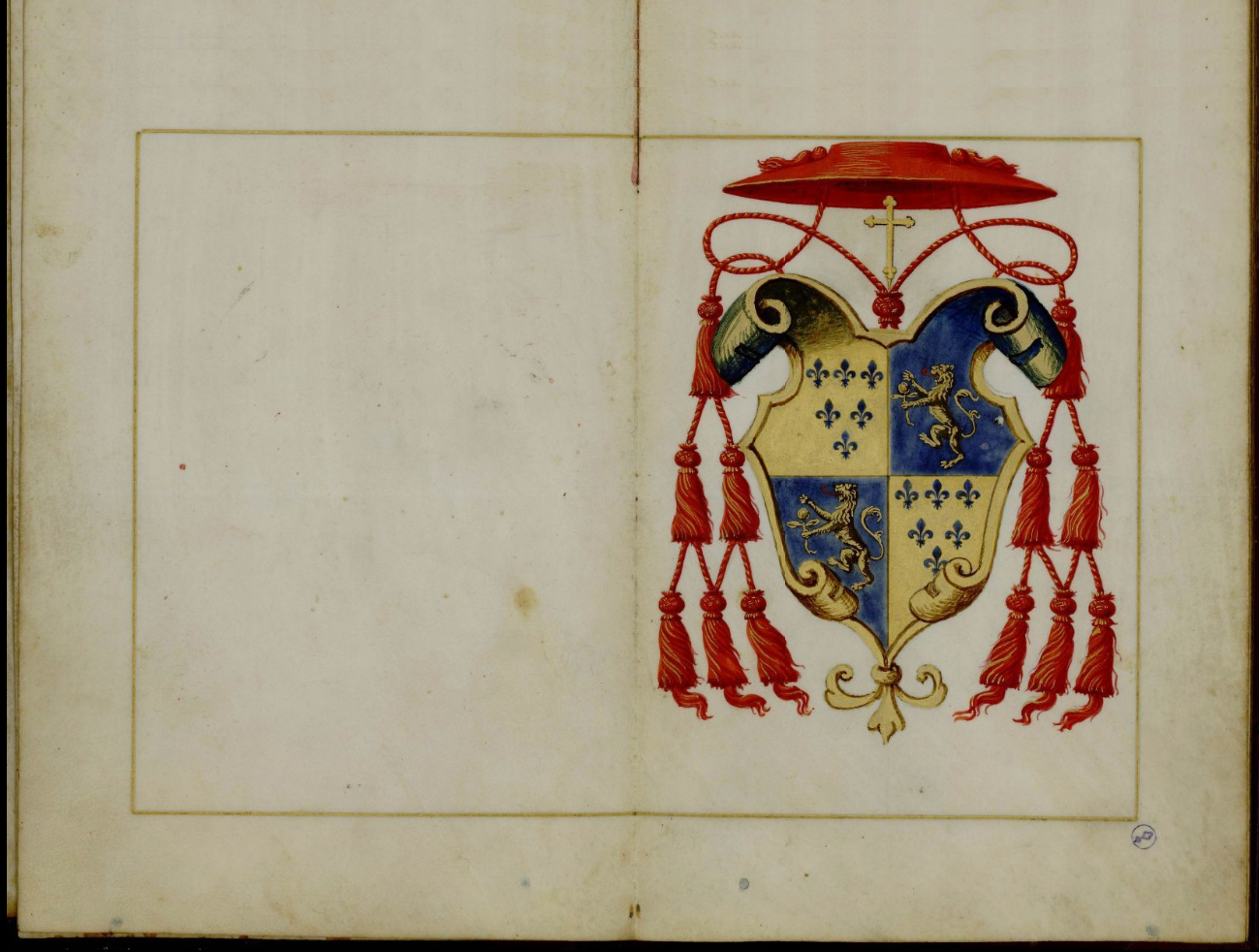
Questo atlante portolano è attribuito a Battista Agnese (1514-64), uno dei più importanti cartografi italiani del Rinascimento. Di origine genovese, Agnese fu attiva a Venezia dal 1536 fino alla morte. È probabile che abbia diretto una tipografia a tutti gli effetti dove sono state realizzate le sue mappe. Ha prodotto circa 100 atlanti, di cui più di 70 esistono ancora, sia con la sua firma che attribuiti al suo studio. Considerati opere d'arte per la loro alta qualità e bellezza, gli atlanti sono per lo più portolani, o atlanti nautici, stampati su pergamena per funzionari di alto rango o ricchi mercanti piuttosto che per l'uso in mare. L'atlante qui presentato contiene tabelle di declinazione, una sfera armillare, lo zodiaco e mappe che mostrano: le coste orientali e occidentali del Nord America; l'Oceano Atlantico e ad ovest dall'Arabia fino alla costa orientale del Sud America dalla forma speculativa; la regione dall'Africa al sud-est asiatico; Europa occidentale; Spagna e Nord Africa; il Mediterraneo (varie mappe); il mare nero; e la regione intorno alla Grecia e l'attuale Turchia. Comune alla maggior parte degli atlanti di Agnese e qui presente, oltre a una mappa mundi ovale con putti, o teste di vento, in nuvole blu e oro, che rappresentano i classici 12 punti del vento da cui si sono evoluti i moderni punti cardinali. Questo manoscritto è stato realizzato per il cardinale Guido Ascanio Sforza di Santa Fiora (1518-64), il cui stemma si trova al foglio 1 recto. La rilegatura ha un piccolo compasso coperto da un disco di vetro incastonato nel contropiatto. Il modo in cui il mondo conosciuto è rappresentato come una proiezione ovale con paralleli equidistanti è diventato di uso comune in seguito, soprattutto grazie al cartografo, ingegnere e astronomo piemontese Giacomo Gastaldi (circa 1500--circa 1565) e al cartografo fiammingo Gerardus Mercator (1512--94). L'atlante appartenne a Vittorio Emanuele II, re di Sardegna dal 1849 al 1861 e primo re dell'Italia unita dal 1861 fino alla sua morte nel 1878.


Battista Agnese (1514-64) was a masterful geographer and mapmaker. Born in Genoa, he worked in Venice from 1536 to 1564 and became one of the most important figures in Renaissance cartography. Researchers differ on the total number of manuscript atlases created by Agnese; he produced at least 39 portolan, or maritime, atlases, ten of them signed and dated. All are distinguished by their neat calligraphy and are esteemed for their high quality and beauty. None was intended for use on board ship; they served as ceremonial gifts and as adornments to the libraries of the well-to-do. This atlas contains 20 pages of maps. A heraldic bookplate of the court library in Munich appears at the front of the book, followed by declination tables and the zodiac. On the oval world map, the continents appear in green, with somewhat speculative outlines of North and South America. Cherubs, or wind heads, representing the classical twelve-point winds from which modern compass directions evolved surround the map. Other maps show the Pacific, Atlantic, and Indian Oceans, and the Baltic, Mediterranean, and Black Seas. Characteristic of all Agnese atlases are the routes of travels recorded on the map of the world. The Munich copy presented here shows, in blue, Magellan's voyage from Lisbon, through the straits named after him, to the Moluccas, and the return voyage of the one surviving ship around the Cape of Good Hope (1519-22). A second line—faintly discernible, originally inscribed in silver-traces Pizarro's voyage of 1521, which started from Cadiz, Spain, and crossed the Isthmus of Panama to reach the west coast of South America, thus inaugurating the Spanish conquest of Peru. // Bayerische Staatsbibliothek, Department of Manuscripts and Rare Books, 2019

https://www.digitale-sammlungen.de/en/view/bsb00003259?page=,1


https://www.digitale-sammlungen.de/en/view/bsb00003259?page=,1

https://www.loc.gov/resource/gdcwdl.wdl_19478/?r=-0.434,0.298,1.576,1.001,0

https://www.digitale-sammlungen.de/en/details/bsb00003259


o de cima é referente 

a Biblioteca da Bavária Alemanha

Munique Munchen Bibliothek


Você quis dizer: munchen Bibliothek

Resultados da pesquisa


Münchner Stadtbibliothek - Home

https://www.muenchner-stadtbibliothek.de
Traduzir esta página
Sommer in der Bibliothek – Das neue Quartalsprogramm Mai, Juni, Juli der Münchner Stadtbibliothek ... Aktuelle Coronaregeln in der Münchner Stadtbibliothek.

Munich Digitization Center (MDZ) - Homepage - Münchener ...

https://www.digitale-sammlungen.de › ...
Traduzir esta página
Logo of the MDZ: Münchener DigitalisierungsZentrum, Digitale Bibliothek. Navigate to main page ... Scannen mit dem Münchner Finger. The Munich DigitiZation ...

a seguir o livro que está na Biblioteca Mundial WDR.org

About this Item

Title
Portolan Atlas of Battista Agnese.
Other Title
Portolano
Summary
This portolan atlas is attributed to Battista Agnese (1514-64), one of the most important Italian Renaissance cartographers. Of Genoese origin, Agnese was active in Venice from 1536 until his death. He is likely to have directed a full-fledged printing house where his maps were made. He produced approximately 100 manuscript atlases, of which more than 70 still exist, either with his signature or attributed to his studio. Considered works of art for their high quality and beauty, the atlases are mostly portolan, or nautical, atlases printed on vellum for high-ranking officials or wealthy merchants rather than for use at sea. The atlas presented here contains declination tables, an armillary sphere, the zodiac, and maps showing: the east and west coasts of North America; the Atlantic Ocean and west from Arabia to a speculatively shaped east coast of South America; the region from Africa to Southeast Asia; Western Europe; Spain and North Africa; the Mediterranean (several maps); the Black Sea; and the region around Greece and present-day Turkey. Common to most Agnese atlases and present here as well is an oval mappa mundi with cherubs, or wind heads, in blue and gold clouds, which represent the classical 12 wind points out of which evolved the modern compass points. This manuscript was made for Cardinal Guido Ascanio Sforza di Santa Fiora (1518-64), whose coat of arms is found on folio 1 recto. The binding has a small compass covered by a glass disc embedded in the pastedown. The way in which the known world is represented as an oval projection with equidistant parallels came into common use later on, mainly thanks to the Piedmontese cartographer, engineer, and astronomer Giacomo Gastaldi (circa 1500--circa 1565) and the Flemish cartographer Gerardus Mercator (1512--94). The atlas belonged to Victor Emmanuel II, king of Sardinia from 1849 to 1861 and the first king of united Italy from 1861 until his death in 1878.
Contributor Names
Agnese, Battista, 1514-1564 Cartographer.
Sforza di Santa Fiora, Guido Ascanio, 1518-1564 Patron.
Victor Emmanuel II, King of Italy, 1820-1878 Owner.
Created / Published
[place of publication not identified] : [publisher not identified], [1536 to 1564]
Subject Headings
-  1536 to 1564
-  Coastlines
-  Discoveries in geography
-  Mappae mundi
-  Portolan charts
Notes
-  Title devised, in English, by Library staff.
-  Original resource extent: 15 folios (12 maps) : parchment ; 20.6 x 13.8 centimeters.
-  Reference extracted from World Digital Library: Maria Rosaria Manunta, "Schede," in Biblioteca Reale Torino, edited by Giovanna Giacobello Bernard (Florence: Nardini, 1990).
-  Original resource at: Royal Library of Turin.
-  Content in Latin.
-  Description based on data extracted from World Digital Library, which may be extracted from partner institutions.
Medium
1 online resource.
Digital Id
https://hdl.loc.gov/loc.wdl/wdl.19478
Library of Congress Control Number
2021668747
Online Format
compressed data
pdf
image
LCCN Permalink
https://lccn.loc.gov/2021668747
Additional Metadata Formats
MARCXML Record
MODS Record
Dublin Core Record
IIIF Presentation Manifest
Manifest (JSON/LD)


Seeatlas (Alte Welt und Terra Nova) - BSB Cod.icon. 136

By
Battista Agnese
Creator
  • Agnese, Battista, 1514-1564AuthorGND: 119115115
Subject
  • Portolan
Published
  • Venedig
Date
1541 - 1542
Extent
15 Bl. - Pergament
Dimensions
22,5 x 16,5 cm
Languages
Latin; Spanish
Notes
  • Portolanatlas
  • Kurzaufnahme einer Handschrift
Description
Battista Agnese (1514-64) was a masterful geographer and mapmaker. Born in Genoa, he worked in Venice from 1536 to 1564 and became one of the most important figures in Renaissance cartography. Researchers differ on the total number of manuscript atlases created by Agnese; he produced at least 39 portolan, or maritime, atlases, ten of them signed and dated. All are distinguished by their neat calligraphy and are esteemed for their high quality and beauty. None was intended for use on board ship; they served as ceremonial gifts and as adornments to the libraries of the well-to-do. This atlas contains 20 pages of maps. A heraldic bookplate of the court library in Munich appears at the front of the book, followed by declination tables and the zodiac. On the oval world map, the continents appear in green, with somewhat speculative outlines of North and South America. Cherubs, or wind heads, representing the classical twelve-point winds from which modern compass directions evolved surround the map. Other maps show the Pacific, Atlantic, and Indian Oceans, and the Baltic, Mediterranean, and Black Seas. Characteristic of all Agnese atlases are the routes of travels recorded on the map of the world. The Munich copy presented here shows, in blue, Magellan's voyage from Lisbon, through the straits named after him, to the Moluccas, and the return voyage of the one surviving ship around the Cape of Good Hope (1519-22). A second line—faintly discernible, originally inscribed in silver-traces Pizarro's voyage of 1521, which started from Cadiz, Spain, and crossed the Isthmus of Panama to reach the west coast of South America, thus inaugurating the Spanish conquest of Peru. // Bayerische Staatsbibliothek, Department of Manuscripts and Rare Books, 2019
Content type
  • Map
Manufacturing type
  • Manuscript
Media type
  • Book
Identifier
  • OCLC: 163414503
  • BSB-Hss: BSB-Hss Cod.icon. 136
B3Kat ID
BV021591576
BSB ID
9400599
Holding institution
München, Bayerische Staatsbibliothek
Call number
Cod.icon. 136
Shelf group
  • Codices iconographici - Bildhandschriften mit wenig oder nur erläuterndem Text
URN
urn:nbn:de:bvb:12-bsb00003259-9
Digital Object ID
bsb00003259
Extent
23 scans
Digitized
12/13/2007
Digitized by
Bayerische Staatsbibliothek

In collection


https://daten.digitale-sammlungen.de/bsb00001421/images/index.html?fip=193.174.98.30&seite=405&pdfseitex=
https://daten.digitale-sammlungen.de/0002/bsb00020245/images/index.html?id=00020245&groesser=&fip=193.174.98.30&no=&seite=7
às maio 01, 2022
Compartilhar
‹
›
Página inicial
Ver versão para a web

Quem sou eu

Minha foto
MariaChiquinha
Relações Públicas em MARTE
Ver meu perfil completo
Tecnologia do Blogger.